The 2007 hottest holiday gadget gift

For the past few years, the Apple iPod has been the hottest holiday gadget on just about everyone’s wish list. While I still think the iPod and iPhone will be hot sellers this year, I think an even bigger seller will be portable GPS navigation units. I wrote a review of one that I bought as a gift, the Navigon 2100 and the response to that review has been overwhelming. It’s taken a life of its own and the number of comments dwarf my very popular iPhone review. Now that GPS units have fallen well below the $200 mark, they are much more attractive to casual buyers. I plan to give away at least 3 this year. Everyone I know (or at least one ones on my list) are all set with iPods. So it’s all about GPS’s.


My top picks in this category are the:

Garmin Nüvi 660 (for the one you REALLY love 🙂 )

Garmin Nüvi 360

Garmin Nüvi 200 (great entry level unit)

Navigon 2100

TomTom One 3rd Edition


There are deals to be had out there! So do some shopping around.

Nikon D300 + N2 di-GPS = FUN!

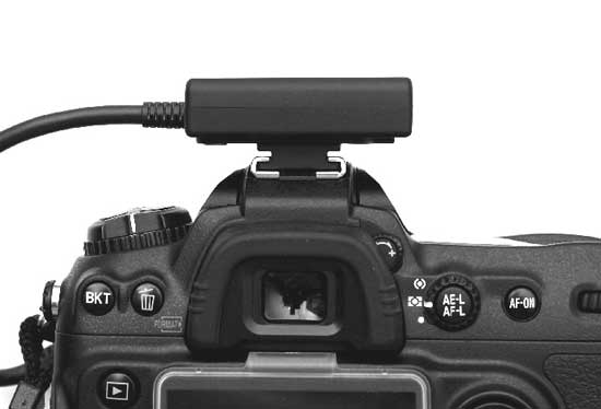
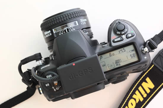
I have really been enjoying my New Nikon D300 camera and there really isn’t anything that I don’t like about it. It’s FAST, takes incredible shots and has all the bells and whistles that I’ve always wanted. Although the Nikon D300 doesn’t have a GPS unit built-in, it does now feature direct support for one and there is even a GPS menu on the camera itself. I bought the N2 di-GPS which works directly with select Nikon & Fuji DSLRs. It arrived this week and it wasn’t until yesterday during lunch that I got a chance to take it out for a spin. The first thing I said to myself when I opened the box was, “wow, this is much smaller than I imagined!” It’s not much bigger than a pack of gum. Very lightweight and easy to travel with. Although it’s designed to sit on the hot-shoe, it’s doesn’t have to. The integrated mount will also attach to the camera strap. There is no battery in it as it gets its power directly from the camera via the cable that attaches to the D300’s 10 pin remote terminal.

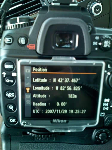
GPS menu built-in to the New Nikon D300 and D3


Once you connect the cable, there is only one switch on the device and it switches from OFF, to Auto, to ON. Do I need to explain OFF? Didn’t think so. In the Auto position the GPS unit will turn on and off with the camera. This will probably yield the best battery life. However, each time the unit is turned on with the camera in this mode it will have to potentially acquire the satellite signal again. In the ON position, it stays on and connected to the GPS satellites regardless if the camera is on or not. Of course this will ultimately drain the camera’s battery faster. I recommend the ON position if you are shooting, then moving then shooting again. If you’re going to use it off and on throughout the day, then Auto is probably best. From a cold start it took about 15-20 seconds to acquire a GPS signal. There is a clear indicator right on top that flashes red when it is searching and stays solid red when it has locked on (Sony could learn from this!).

After connecting the N2 di-GPS and turning it on I was ready to shoot. The beauty of this unit is that the GPS information (longitude and latitude) is inserted right into the metadata of each shot as you take them. No need for post processing when you return to your computer. Since I use Adobe Photoshop Lightroom I can take advantage of this data instantly by clicking the little GPS button in the metadata panel which will automatically take me to the location that I was shooting in on Google Maps.


I took this shot at the New Partridge Creek Mall here in Michigan.


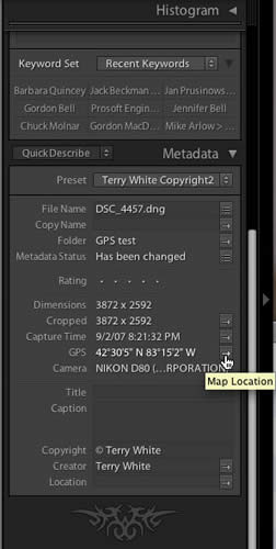
When I look at the image above in Adobe Photoshop Lightroom, I can see the GPS coordinates in the metadata panel

When I click the little arrow to the right of the GPS coordinates, Lightroom takes me to my browser and automatically loads those coordinates in Google Maps for me (you can click the image above for the same experience).

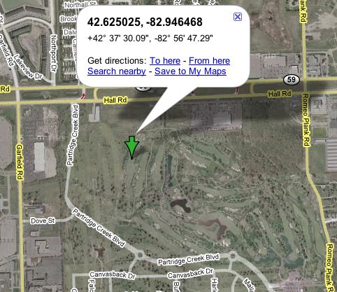
The interesting thing here is that apparently this map hasn’t been updated yet because it doesn’t show the mall on the satellite view 🙂 The mall was just completed and opened in October 2007.

I found the accuracy to be decent, but not great. What I mean by this is that it seems to take few moments to update once you’ve moved. I took some shots just walking around my yard and when I got back to the computer, although I had moved, a couple of the shots were still showing the coordinates from shots taken a few moments earlier. One shot showed that I was in my neighbor’s yard.


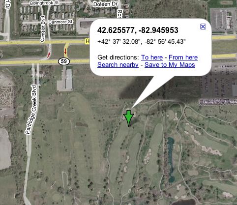
Here’s a shot I took in my backyard. OK, I’m kidding, this was taken at the Partridge Creek Mall. Normally I would have stepped back to get the whole tree, but there were two security guards waiting to tackle me if I even thought of pointing my camera at a store display (which is frowned upon at most malls).

This shot was taken maybe 50-60′ from the Apple store shot above.


Bottom Line

If you want to do some geotagging and map all the places that you shoot and you have one of the supported cameras, you can’t go wrong with this GPS unit. It’s painlessly simple to use and integrates beautifully. The N2 di-GPS goes for $238+$45 S&H. So it’s not cheap (neither are the cameras it supports), but if having GPS data automatically inserted into your images is your thing, this is the one for you.

Supports Nikon D3*, D300*, D2XS, D2X, D2HS & D200, Fujifilm S5 Pro.
*Nikon added new GPS function to D3 and D300. The new function resolved the battery drain issue. The new option in the menu let the user to select the metering system to stay on or auto off when GPS data is received to reduce the power consummation.

Also see my review on the NEW di-GPS Pro!


Hey! I made it into Newsweek

It may not be a feature article on me (yet 🙂 ), but when writer Daniel McGinn was researching for an article that he was writing on Garmin and GPS units he came across my blog and tracked me down at work. Needless to say that when my admin passed me the message I was stunned. I called Dan back and we talked about GPS units and where I thought the industry was headed. He wrote a pretty elaborate article and you can see my "small" quote on the bottom of page 3.

Speaking of GPS units, be sure to check out my review of the Navigon 2100 below.

Navigon 2100 Portable GPS Review


My dad dropped a subtle hint that he would like to have a GPS unit for his car. So being a good son, I began looking for one for him that will be his holiday gift this year. Keep in mind that my dad is 78 and not the least bit technical, so this GPS would have to be pretty easy to use. Although I’m a fan of the Garmin Nüvi line of GPS units, they would be overkill for his needs. So I started looking at other brands. I came across a reference for Navigon and they have a feature called "3D Reality View" This is a photo realistic view of complex highway lane changes and exits. So I stumbled upon a sale at Staples.com and snagged the Navigon 2100 for a mere $179.99 which was $45 off their regular price and the lowest price GPS I could find with the features I wanted. The Navigon 2100 arrived, but I got off to a rough start. I wanted to set the unit up before giving it to him (yeah, I wanted to play with it too) and it’s a good thing I did. Out of the box, when I turned it on I got an error that indicated that the map files were invalid/not compatible. The Navigon 2100 comes with a SD card loaded with all the maps and POIs (Points of Interests). I called tech support and got connected to an English speaking rep right away. I told him about the issue and he informed me that some of the units that went to Staples got "bad" cards. He took my info down and overnighted me a new SD card. He also told me that I could keep the old card and use it for whatever I wanted to. I decided to copy the new card onto the old one as a backup. That worked fine. With the new/proper card installed the Navigon 2100 powered right up and I was presented with an easy to follow menu. I keyed in my dad’s address so that he could use the "Take Me Home" button whenever he needed to and be routed to his house no matter where he was in the country. While I had the unit open, I decided to take it for a spin. I assembled the suction cup mount and took the GPS for a test drive. I was impressed with how fast it starts up and acquires a satellite signal.


Real world testing

One of the things that makes or breaks a GPS unit is how easy it is to input your destination. This was also going to be the determining factor as to whether or not I felt my dad would be able to use it. I really liked the fact that you have the option of keying in the city OR just the zip code! I also liked having the choice of entering the city, street and address OR the street, address and city. Unlike many units the Navigon 2100 remembers the last city you used so that you don’t have to key it in each time. Now on the down side and the thing I’m worried about the most is that the on screen text is kind of on the small side. If I had to guess I would say that some of the text is as small as 8pt type. Also on some of the displays the on screen buttons aren’t as large as they could be. The other thing on the down side is that there is no "bean bag" mount option. I’m not a fan of suction cup mounts, although the one they include stayed on my window the whole time with no issues.


Great features

It’s clear that the Navigon engineers looked at the other GPS units out there and tried to build a better unit. I had to keep reminding myself that this GPS is half the cost of others and has all the features you’d expect in a higher-end unit and MORE! Let’s get the basics out of the way. They 2GB SD Card includes the maps for the entire US and Canada. The Navigon 2100 features "Text-to-Speech" so rather than saying "turn right in 200 feet", it says "turn right on Woodward Avenue, turn here". There are also thousands of POIs and you can input your favorite destinations and save them. These are the features I would expect to find in any modern GPS unit. Where the Navigon 2100 steps ahead of the pack is in the little things. First of all the 2100 is about the size of my Nüvi 360 if not a little thinner. Most units in the $200-$300 range are much thicker. Not only does the 2100 show you where you are on the map it also shows the speed limit of the road you’re on. By default there are speed warnings built in (which you can change) that are set to 10 miles over on the highway and 5 miles over elsewhere. Of course I had to test this out, so I went over 75mph in a 65mph zone and the voice said "Caution" and displayed a little yellow triangle next to the speed limit sign in the upper left of the display. I was also impressed with the display of the POIs along the way. Rather than the typical gas pump logo on the side of the road representing a gas station, it actually displayed the "Mobil" logo as I passed near the station. Now of course they don’t have logos for all businesses/POIs, but it did display the names of restaurants as I passed near them. This blew me away. Imagine how helpful that would be if you’re driving in an unfamiliar area.


The killer feature was the one that caught my eye in the first place and that was the "3D Reality Viewâ„¢" This view automatically pops up when you’re approaching a complex interchange or exit. As you can see in the photo above I was instructed to stay on I-696 headed towards Lansing and the photo realistic display mimics the actual road signs that you can see in the upper left corner of the photo. The orange arrows on the display clearly indicate the lane you should be in so there is no way that you could take the wrong exit. This feature ROCKS! It totally takes the guess work out of navigating these kind of exchanges. I’ve never seen anything like this even on units that cost much more.


The Navigon 2100 includes the GPS unit, an SD card with maps and POIs for the lower 48 states (the 2120 is the same unit, but with maps for North America excluding Mexico), an Auto charger for charging the built-in Lithium ION battery, a suction cup mount and a quick start guide. For an extra $99 you can buy the Lifetime Traffic feature which is an antenna that plugs into the 2100 and a service that can automatically re-route you around traffic jams. You can also spring for the Zagat Survey Ratings and Reviews feature which includes 21,000 entries. Ratings of hotels, restaurants and entertainment in the area. This add on goes for $39.99.


The Bottom Line

GPS units don’t have to cost a fortune. The Navigon 2100 proves that. I was floored by the number of features that were included in this relatively low cost unit. I would like to have seen a wall charger included for charging the unit in the house, but hey for less than $200 what you do get is a great bargain. You can catch the Navigon 2100 for $179.99 while it’s on sale at Staples or you can get it for $209.94 at Amazon.com. This would make an EXCELLENT Gift!

Hey, I made Newsweek!


Speaking of GPS units check out this article in Newsweek where yours truly [I] was referenced on page 3.

A GPS for your digital camera

Sony GPS

I’m a bit of a GPS buff. I have them in my cars and I even have a portable Garmin Nuvi 360 for travel and use in rental cars. So it’s quite natural that when I learned about this
Sony Unit for Digital Still Cameras that I was quite intrigued. I actually first saw this unit about a year ago. However, when I read the reviews on Amazon.com I was a little less excited. Some were complaining that it didn’t work that well especially around tall buildings. So I kind of forgot about it until a few weeks ago when I was having dinner with my colleagues and Colin Fleming told me that he had one. So I had to ask, "does it work?" and more importantly, "would you buy it again?" His answers to both questions were YES! Then my next question was (knowing Colin is a Mac user), what app on the Mac did he use to marry the GPS data to the images? You see the Sony GPS comes with an app to add the GPS data that it captures to your images, however it’s Windows only. So Colin turned me on to HoudaGeo which is a $30 Mac app that does just that. It extremely simple and works great.


How does it work?

The concept is simple: You go out on a shoot (outside of course) and you turn on the Sony GPS. It starts a new log file on the device itself and once it connects to a GPS satellite it starts recording your coordinates and the time/date everywhere you go. Then you pick up your camera and start shooting. Since your camera is recording the date and time (very important that you have these set correctly in your camera) of every shot and the Sony GPS is recording the date and time coordinates at the same time all you have to do is match the images with the GPS log file when you return to your computer.


What’s my workflow?

Since I shoot primarily in Camera RAW and that there are no two camera manufacturers use the same RAW format, I use Adobe’s Digital Negative .DNG format (an open standard for Camera RAW files). The HoudaGeo app can’t embed the GPS data in proprietary RAW formats anyway. However, it can embed this data in .DNG files as well as JPEGs of course. Normally I would just import my images directly into Adobe Photoshop Lightroom. However, when I shoot landscapes and want to use the GPS data from the Sony GPS, I plug in my memory card into my Mac and then I use the FREE Adobe DNG Converter (Mac|Win)to convert my Nikon’s proprietary .NEF files into .DNG files directly from the memory card into a folder on my drive. I then use the HoudaGeo app to import the .DNG files and then the Sony GPS log file that contains all the GPS data. The 3rd step in the app is to click that actually writes the GPS data to the .DNGs (or JPEGs).

Once the images have the GPS data imported into them, I then import (reference) the images into Lightroom. From there I can do all the great things that Lightroom allows me to do, but I can also bring up any image in Lightroom and not only see the GPS longitude and latitude, but I can also click one button that automatically takes me to those coordinates in Google Maps and gives me a satellite view of where the shot was taken.

Here’s the shot I took at a nearby park


Here’s the GPS data showing for that shot in Adobe Photoshop Lightroom


After clicking the "Map Location" button in Lightroom, I was taken directly to a satellite view in Google Maps.


What’s hot and what’s not?

So far it works as advertised and it’s very easy to use. Basically just turn it on. However, there is definitely room for improvement. For example, there is only one status indicator that either blinks fast green when it has NOT locked on to a satellite or slow green when it has. Guys, how hard would it have been to use two different color LEDs or lights. Green is locked on and Red isn’t. I’m constantly looking at it trying to figure out "is that a slow blink or fast blink because there isn’t that much difference between them. Also Colin tells me that it doesn’t behave well when it’s dangling from say your belt, which is clearly the way it looks like you would use it. Instead I put a strip of velcro on it to attach to a vest or brim of a baseball cap (looks dorky, but it works). Lastly, it would have been nice to include a Mac app so that I wouldn’t have to spend an additional $30 for one. However, the HoudaGeo app is probably better than what Sony would have come up with anyway.


Would I buy it again?

So far the answer is yes! I’ve only used it in testing a few times so far, however each time it had no problem locking on to a satellite and since I don’t plan to use it much around tall buildings, that’s not a concern for me. I can’t wait to take it on my next trip out in the wild and shoot some of this country’s most beautiful landscapes. However, next time I’ll actually be able to "show" people "where" the shot was taken. Not sure how useful it will really be, but it sure is FUN! The
Sony GPSCS1KA GPS Unit Kit for Most Digital Still Cameras is $104.57 at amazon.com

Also check out this CNET article on the subject of Geotagging your photos.

The Bean Bag is back in style

I love my Garmin Nuvi GPS however, I’m not a fan of windshield suction cups. While they work for the most part, I primarily use my Nuvi in rental cars and therefore have to move the mount from car to car each time I travel. I’ve had the Nuvi literally fall off the window on more than one occasion while driving. While the Nuvi has survived the fall each time, it was a pain in the butt (and a hazard to my fellow motorists) to get it back on the windshield. So I started looking for other mounting solutions when I came across this “Portable Friction Mount – ie. Bean Bag” on Garmin’s site. In order to use this mount you also need the Automotive Mount. The Automotive Mount is designed to stick permanently on your dashboard as some states don’t allow anything to be mounted to the windshield (probably for the reasons above). However, it does slide neatly and not permanently into the Bean Bag mount. So in theory you could use the base that comes with the Automotive Mount in your car and still travel with the Bean Bag mount and the part that attaches to the Nuvi for other/rental cars. This isn’t a concern for me as my personal vehicles all have factory navigation in them already.

I took the Bean Bag mount for a test drive and it stayed in place even on those Indy 500 style turns that I’m known for. It’s also neat to just pickup the whole thing when you arrive and go inside. If you find that suction mounts “suck (or don’t suck)”, then I highly recommend this solution!