

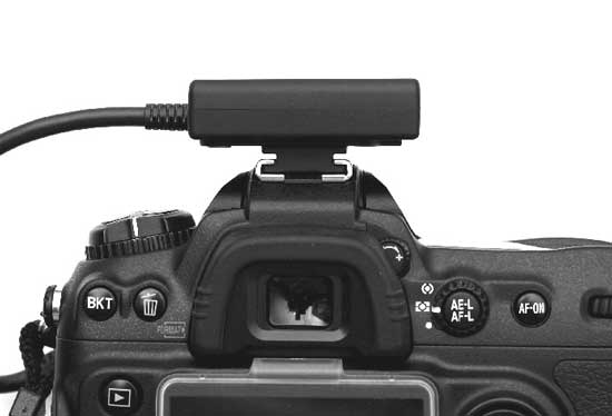
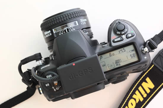
I have really been enjoying my New Nikon D300 camera and there really isn’t anything that I don’t like about it. It’s FAST, takes incredible shots and has all the bells and whistles that I’ve always wanted. Although the Nikon D300 doesn’t have a GPS unit built-in, it does now feature direct support for one and there is even a GPS menu on the camera itself. I bought the N2 di-GPS which works directly with select Nikon & Fuji DSLRs. It arrived this week and it wasn’t until yesterday during lunch that I got a chance to take it out for a spin. The first thing I said to myself when I opened the box was, “wow, this is much smaller than I imagined!” It’s not much bigger than a pack of gum. Very lightweight and easy to travel with. Although it’s designed to sit on the hot-shoe, it’s doesn’t have to. The integrated mount will also attach to the camera strap. There is no battery in it as it gets its power directly from the camera via the cable that attaches to the D300’s 10 pin remote terminal.
GPS menu built-in to the New Nikon D300 and D3
Â
Once you connect the cable, there is only one switch on the device and it switches from OFF, to Auto, to ON. Do I need to explain OFF? Didn’t think so. In the Auto position the GPS unit will turn on and off with the camera. This will probably yield the best battery life. However, each time the unit is turned on with the camera in this mode it will have to potentially acquire the satellite signal again. In the ON position, it stays on and connected to the GPS satellites regardless if the camera is on or not. Of course this will ultimately drain the camera’s battery faster. I recommend the ON position if you are shooting, then moving then shooting again. If you’re going to use it off and on throughout the day, then Auto is probably best. From a cold start it took about 15-20 seconds to acquire a GPS signal. There is a clear indicator right on top that flashes red when it is searching and stays solid red when it has locked on (Sony could learn from this!).
After connecting the N2 di-GPS and turning it on I was ready to shoot. The beauty of this unit is that the GPS information (longitude and latitude) is inserted right into the metadata of each shot as you take them. No need for post processing when you return to your computer. Since I use Adobe Photoshop Lightroom I can take advantage of this data instantly by clicking the little GPS button in the metadata panel which will automatically take me to the location that I was shooting in on Google Maps.
Â
I took this shot at the New Partridge Creek Mall here in Michigan.
Â

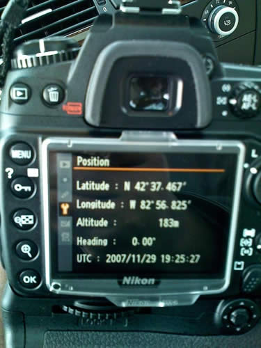
When I look at the image above in Adobe Photoshop Lightroom, I can see the GPS coordinates in the metadata panel

When I click the little arrow to the right of the GPS coordinates, Lightroom takes me to my browser and automatically loads those coordinates in Google Maps for me (you can click the image above for the same experience).
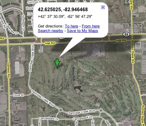
The interesting thing here is that apparently this map hasn’t been updated yet because it doesn’t show the mall on the satellite view 🙂 The mall was just completed and opened in October 2007.
I found the accuracy to be decent, but not great. What I mean by this is that it seems to take few moments to update once you’ve moved. I took some shots just walking around my yard and when I got back to the computer, although I had moved, a couple of the shots were still showing the coordinates from shots taken a few moments earlier. One shot showed that I was in my neighbor’s yard.
Â
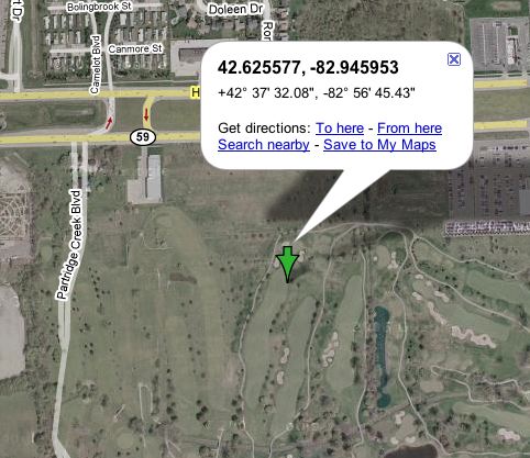
Here’s a shot I took in my backyard. OK, I’m kidding, this was taken at the Partridge Creek Mall. Normally I would have stepped back to get the whole tree, but there were two security guards waiting to tackle me if I even thought of pointing my camera at a store display (which is frowned upon at most malls).

This shot was taken maybe 50-60′ from the Apple store shot above.
Â
Bottom Line
If you want to do some geotagging and map all the places that you shoot and you have one of the supported cameras, you can’t go wrong with this GPS unit. It’s painlessly simple to use and integrates beautifully. The N2 di-GPS goes for $238+$45 S&H. So it’s not cheap (neither are the cameras it supports), but if having GPS data automatically inserted into your images is your thing, this is the one for you.
Supports Nikon D3*, D300*, D2XS, D2X, D2HS & D200, Fujifilm S5 Pro.
*Nikon added new GPS function to D3 and D300. The new function resolved the battery drain issue. The new option in the menu let the user to select the metering system to stay on or auto off when GPS data is received to reduce the power consummation.
Also see my review on the NEW di-GPS Pro!


You are making us all so jealous!
Hi Terry.
On your recommendation, I bought the GPS for my D300. It arrived yesterday, and I’m looking forward to trying it out this weekend.
Cheers,
-Ade
Ade,
Let us know how you like it?
T
Hi,
thanks for your article! I’ve a question: is the delay for updating really so bad?
Walter
Can the D300 and the GPS adapter be modified or added with any other adapter to make it work via Bluetooth to connect to my Garmin nuvi 680?
Regards,
Dennis
Well, after opening my D3 the other day and trying to compare it’s mass to it’s expected (Canon 5D-like) benefits I’m mildly curious why Nikon didn’t just throw the little GPS dongle inside the body. They obviously knew of its existence.
Really. It’s otherwise kinda dorky (or Homeland Security-like) and for scouting doesn’t seem to have any way to know the compass points (like West for sunsets!) but it is fun. And, yes, from Google Maps/Earth you could figure the compass position easily. I guess since the D3 has 2 CF card slots one of them could be for a Wi-Fi n “card” like the new SD Wi-Fi card. Or how about a CF card GPS?
Oh, wait, that’s next year!
Jim,
I hear ya! When I saw how small this unit was, one of my first thoughts was “why couldn’t they have built this into the body?” Especially for the D3 if nothing else.
Dennis,
This adapter only works as described (as far as I can see). So no bluetooth and no integration with other GPS’s. Also no bluetooth on the camera.
One issue that may or may not be influencing the additona of GPS is that there is a certain amount of noise from the Nikon’s electroincs that can cause SiRF IIIs not to be able to achieve a lock.
Hi, great wee GPS. can you insert the gps data into the raw files or dos it only work with jpeg files?
Many thanks
who-said-that,
I shoot in RAW almost exclusively. Yes, the GPS data does go into the .NEF files as well as the conversion to .DNG from there.
WOW, lightening reply!. So you simply plug the GPS in to the D300, it inserts the data directly in to the NEF file, you then import in to Lightroom and magically the GPS data is there to see.. 🙂
If so, thats so cool.
I have a D80 but looking at getting a couple of D80 bodies instead of the D300 for now.
10mp is ok for now but I like the idea of a DSLR per lens I use and therefore a reduce dust problem and faster shooting, just have to grab the body with the right lens on… Is that a crazy idea???
Thanks for sharing and merry christmas
who-said-that,
Yes, it’s just that simple (like magic).
Merry Christmas to you too.
Just wondering if you can shoot via the cable release if the gps is already in the socket?
Can you piggyback the to connections into the one socket?
Thanks
Like most I am also interested in the capabilities of attaching a GPS to a camera, am currently looking at upgrading my camera from a D70S and taking the next steo to a D300. I could see this as a very useful tool for work, as being a civil engineer for a council, often need to take pictures of accidents, road deteriation and just projects in general and being able to display this on a GIS database.
Could someone tell me the accuracy of the GPS, as I will be asked this at work. Obviously due to its small size I am execting around 5-10 metres (15-30 ft).
Thanks
I too am only hesitating on purchasing one because of concern about losing the cable release capability. Photo purists like myself use a tripod and cable release whenver we can. Is there any work-around for this?
On the camera display there seems to be a heading display on degrees, on the Photoshop display it seems to only give a very course W compass heading. Is that a matter of setup? I’m looking for at least a 10 degree resolution. Is that possible?
Terry,
Thanks for the insight. Can you speak to the degree to which the GPS drains the camera battery (relative to normal camera operation)?
Just picked up a D300 and had a Sony H5 with a Sony GPS ( the sony was just terrible on the mapping locations and I sent it back) A lot depends on the timing interval and your location. My question is this unit is $125 more than the Sony, I can assume it can get me within 100 to 300 yards of the GPS shot?? The sony was a 1/2 mile off. I map for a living and would enjoy an semi accurate GPS for my d300.
Thanks
we are producing GPS receiver which can connect with the hot shoe of the digital camera directly. We would like to know the needs of the customers Then we can improve our products. Our website is http://www.solmeta.com. Thank you for your help.
In bryan msg the web site is written with too much dots!
Correct URL is http://www.solmeta.com/en/
IMHO it seems interesting
Best regards
Any chance Nikon uses the GPS signal to set its internal clock? What about the time in the EXIF data– is that from the Nikon’s time setting or from the GPS???
Hello all,
I already have a D300 with the 10-pin plug-to-serial adapter, which I intended to use with an old Garmin eTrex (and its serial cable) that I’ve had laying around for a while. However, the Garmin is annoying large, and its cable annoyingly long & bulky. Having already purchased the 10-pin plug-to-serial adapter, I was wondering if anyone has considered mating it to a Bluetooth Serial adapter (like this one: http://tinyurl.com/2mf7pc )? If it worked I could use my ultra-tiny Holux GPSlim 240 (the size of a Minox IIIa)…the whole setup would run a tidy $170 if you bought it all new, and the individual components could be used for any number of things aside from with the camera.
Thoughts?
I found the accuracy to be decent, but not great. What I mean by this is that it seems to take few moments to update once you’ve moved. I took some shots just walking around my yard and when I got back to the computer, although I had moved, a couple of the shots were still showing the coordinates from shots taken a few moments earlier. One shot showed that I was in my neighbor’s yard.
Terry, have you compared accuracy with other GPS receivers? I mean, is inaccuracy inherent to this GPS receiver or is this GPS receiver’s accuracy just as bad/good as other portable GPS receivers? GPS receivers in the consumer domain, I hear, aren’t as accurate as, say, those used by the US Army. If your backyard is small like mine, I would be surprised if you do see difference in lat/long of the four corners of the yard. 🙂
From your description, though, it looks like it is a good tool to have for geotagging pictures. I wish it were cheaper. Actually, more than that I wish Nikon D300 had bluetooth capability…so that it would accept GPS data from inexpensive bluetooth GPS receivers.
I bought the di-GPS after finding this link on Google. It shipped super fast and got here in no time. The set up was completely foolproof.
As for cable shutter release, the di-GPS has a minijack connector for a shutter release cable. The user manual describes the wiring for this shutter release and they even sell the di-GPS in a package containing a cable release as well.
As for whether the camera uses internal clock or GPS time for timestamping photos I haven’t tested it, but the documentation claims that the GPS time is used when available.
Here is a link to a Hong Kong company that sells cables to connect GPS units to Nikons (and lots of other obscure cables)
http://www.pc-mobile.net/nikon-gps.htm
They offer a detachable shutter release that can be used at the same time the GPS is connected.
I ordered cables today, so I do not have an opinion on their quality. They seem to have done some homework, though.
You can also check out Red Hen for their adaptors for the Nikon cameras. Works with your existing Garmin products. (See site for specifics)
I just got my di-GPS, and indeed it is a great add-on. I have tried it on my D3. I expect it to work great on my D-300.
I would love to see a program that gives me a world view and then a slider on a date range. I could then use it to find my photos from a trip.
I could say create a slider for 1 year range, remember I want to find a picture when I was at a certain place and then slide the slider to see where the photos are.
This would make my management of my 100,000 + photos much easier.
I bought one from solmeta company. It is cool. I love it. It has an independent battery.
Terry, have you talked to anyone using the 5D about whether there is a similar product available for those of us in the Canon camp?
For those of you that are asking about bluetooth serial connection there are already two available on the market, one with the option to also connect an shutter realese cable (3.5 mm jack).
I self have the solution from Foolography together with a portable Bluetooth GPS reciever and it works great, no cables etc just a realy small adaptor (2cm x 2 cm) that sits directly into the 10 pin connector.
Unleashed from Foolography
http://www.foolography.com/unleashedxmas.php
Blue2CAN from Red Han system
https://ecommerce.redhensystems.com/pc-47-2-blue2can.aspx
Regars
Stefan
Johnny Sewell,
I haven’t seen anything for the Canon side that connects directly to the camera and doesn’t require any post processing. If I do, I will post it here and probably create a new blog entry too. So stay tuned.
Terry
As a note to those looking at the Bluetooth GPS solution for their Nikons:
At this time Bluetooth GPS receivers with the MTK chipset may not work with the Nikons. The fault seems to be with how the NIKONs interpret the data stream which is slightly different with the MTK chipset when no DGPS is present (albeit NMEA0183 compliant). Maybe a future firmware update will fix this issue but until then stick with SiRFIII chipset based units.
Thanks Terry. I will stay tuned for any Canon info.
I saw on Moose Petersen’s blog that he carries 2 of these units all the time. (probably hard from him to use more than 2 cameras at a time!)
Johnny
http://www.flickr.com/photos/bezdomny/sets/72157603997529380/
http://www.flickr.com/groups/geotagging/discuss/72157603993326205/?search=solmeta
Those are discussing about GPS product for digital cameras
Hi Terry, great blog, thanks for the tips! I was really excited when I saw your review of the DawnTech N2. So much excited, that I had to run right out and buy one. Plus, uh, a new D300. Thanks a lot. (snicker)
I’ve only had the combo for a few hours now and I’m really enjoying getting to know the D300. I’m a long time Nikon user and also an Adobe user – love Lightroom. It’s made me the photographer that I’ve always pretended to be…!
So… my question. I’ve got a handful of images with geo data encoded via the N2 and am using Lightroom. I’ve discovered that Lightroom won’t export GPS data. I use Smugmug and want to be able to export a quick collection to Smugmug (either through a plug in or just exporting jpgs and then uploading to Smugmug). The idea is that I’l use the Google API on Smugmug to map multiple images. But… apparently Lightroom does not export the GPS data!!! Aiiiyeeee.
Any tips would be really appreciated.
danbrew 🙂
For some time now, higher-end Nikon DSLR cameras have had the ability to link with select Global Positioning Satellite (GPS) receivers and record very precise information on the camera’s location at the time each image was captured. Nikon cameras equipped with this feature include the D200, D300, D2Hs, D2X, D2Xs, and D3, as well as the Fujifilm S5 Pro (a D200 derivative). The typical setup involved the camera with a Nikon MC-35 GPS adapter cord attached to its ten pin remote terminal while the other end connected to a PC interface cable connector that was in turn attached to the GPS.
Now, Shenzhen Solmeta Technology Co., LTD (Solmeta, for branding purposes) has produced a camera-specific GPS unit that is dwarfed in both size and weight by the typical hand-held GPS used for this type application in the past, and makes use of a single connection directly to the camera’s 10 pin terminal. For digital users who need or want GPS data for their images, things just got a lot simpler.
Design and Construction
Solmeta has three products in their line – the N1, which is the subject of this review, and the N2 and C1, both soon to appear on the market per a company spokesman. The N2 will feature a compass (heading) function for the D3 and D300, and the C1 will be for other brands of cameras and include the compass function.
The N1 is a light and compact unit, measuring about 2 x 1.25 x .75 inches and weighing in at 50 grams. Contrast that with the dimensions of a Garmin Geko 301 GPS, one of the smaller and lighter Garmins that have been operationally confirmed by Nikon for use with the D300 and D3: 1.9 x 3.9 x .96 inches and 96 grams. Keep in mind that the weight of the Garmin doesn’t include the Nikon and PC adapter cords necessary to complete that installation, while the N1 is ready to go as is. Obviously, weight is not really a major concern here, since the difference between the two systems can be measured in ounces, but it is part of the larger picture that makes the Solmeta system quite simple and easy to use.
For more details please visit
http://www.digitalcamerareview.com/default.asp?newsID=3375
Doh! Figured it out. Galleries in Smugmug have to be public for the Google API to work. Although I was almost certain that Lightroom was not exporting JPGs with geo data, it appears that I was mistaken…
The Smugmug Gallery: http://danbrew.smugmug.com/gallery/4523627_rZfE7/1/266363209_sFmX9
The Smugmug Gallery mapped: http://maps.smugmug.com/?feedType=geoAlbum&Data=4523627_rZfE7
Cool, huh?
Process was pretty straightforward:
1. Connect Dawn Technology N2-diGPS to D300.
2. Take a bunch of pictures.
3. Import NEFs into lightroom. Putz around in lightroom with image control, etc.
4. Export images as JPG.
5. Send to Smugmug.
6. Open Smugmug and say “Map this”.
Nice.
I was wondering…has anyone tried out any of the bluetooth options mentioned in the above posts? Specifically, the foolphotography bluetooth device?
HI,
I’m wondering the same thing as Andrew. I’ve spent a couple of minutes surfing to see if I could find a GPS that was a bluetooth transmitter with no luck at all. Can anyone steer me in the right direction? Who makes a gps unit that will interface with the foolphotography Bluetooth device???
Thanks,
Re.: Bluetooth receivers
Examples:
Holux GPSlim series: http://www.holux.com/JCore/en/products/products_list.jsp?pno=2
GlobalSat Sirf III: http://www.globalsat.com.tw/eng/product_024_00001.htm
Re.: Foolography Unleashed
I personally use the Foolography BT module and I’m generally very satisfied with it. One improvement that is needed on it is the inclusion of a lanyard so that the small module doesn’t get lost.
Hi, Great Review!!!
Looks like just the thing I need for my project (www.singaporevr.com)
Right now, I’m using an N82 with Geotagging and logging it immediately after I shoot my shots
Yes – send $300 bucks to Paypal and a company that doesn’t even publish a country of origin let alone an address. Nor do they reply to email.
It’s not cheap but neither is the camera it supports? Great reasoning. I hope to see $800 camera straps in the future for the D3.
The real question is, WHY DOEN’T NIKON MAKE A GPS INTEGRATED CAMERA OR GRIP? If someone can manufacture them on a kitchen table in Hong Kong, what’s the matter with Nikon?
FYI, the link to the mall has been updated. There’s a building there, now!
And, BTW, thanks for your blog entry! This functionality will be quite beneficial and has convinced me to upgrade from my “classic” D70 to the D300.
Terry,
I’m looking to invest in a GPS for the D3 recently purchased. Just curious if you still recommend this GPS unit or if you’ve found another one that you like better-
as its been a number of months since the original review.
Thanks,
S
Steve,
I absolutely still recommend it and I’ll probably move up to their new model. I’m using it more and more and I just used it yesterday to tag some photos (landmarks) for my upcoming photowalk. It works GREAT!
http://www.flickr.com/photos/terrywhitephotography/sets/72157606681382113/
Excellent! I had always wondered about using GPS with the D300, and nothing could be clearer than your aticle.
I’ve linked up to your piece at :>
Thanks!
How does this work when you shoot from a tripod with a shutter release cable??
Craig, the original model didn’t allow for a cable release to be connected at the same time. The new “pro” model does!
All – I have been using the Di-GPS for quite some time now. I have taken it to Wyoming to do some hiking and have taken it out and about in the city. All-in-all this little unit kicks some serious butt. What I like about it is that it can acquire the signal very quickly if there is no tree cover. It remembers the last place it was, so if you haven’t moved very far it remembers. Worst case for me was, fog, dense tree cover, in a valley and still only took like 40seconds to acquire. If there is a clear sky and no tree cover it can be 1-2 seconds. If you are thinking of getting it, don’t hesitate. The folks over in Hong Kong shipped the thing to me in about 1 day! Amazing!
My solution is a DIY project that almost anyone with a bit of soldering
experience can perform.
http://www.stockholmviews.com/diyphotogear/nikon_mc-35.html
Regards/ Stefan
Has anyone tested this GPS while shooting moving pictures from an automobile, or even more along the lines I am working with, doing aerial photography from an aircraft? Speed ranging from 25-50 mph. Most GPS’ update very quickly now days, especially if it is a newer 5hz unit. I’m wondering how fast the camera refreshes the available data.
Would love to hear back from anyone that knows about this or has tested the gps while in motion other than walking.
Thanks!
David
I also am interested in using this GPS unit for aerial photography. I would like to know if it will need an external antenna if using an aircraft with wings over the plane (Cessna 172).
If so, how will it work with the GP-1?
N2 di-gps is great. But here is a competitive worth considering and that is Geotagger Pro from Solmeta http://www.solmeta.com
It combines data logger and direct input together. Also built in 3 axis compass and level indicator.
I’ve finished my testing of the Easytagger, GP-1, and Garmin Geko GPS units as promised a few days ago. I took 10 images from a fixed location with each of the 3 units, and plotted the locations on Google Earth. I also measured my camera position against visual reference points in Google Earth, and was able to measure the deviations against the “actual” position. I input all of the GPS data from the 30 image files into an Excel spreadsheet to gain a little more clarity in the analysis.
Interesting results, actually a little surprising. Based on my testing, I favor the Easytagger over the GP-1 for a few different reasons, mainly the Easytagger’s better functionality and value. There are a couple of watchouts to consider with the Easytagger as well, but these are things I can live with based on my shooting priorities and preferences. The Garmin Geko that I had so proudly rigged up a few years back really sucked, as it turns out. I thought it would have blown the doors off the others on a technical basis, and get knocked for its bulk and weight, but it didn’t even pass technical muster. Interesting results with lots of details.
I’m curious to hear what other people may have to say based on their experience with any of these GPS units or others. Take this for what it’s worth. I’m not a professional electronics tester and I’m certainly not a professional photographer. I was just really curious so I figured I’d at least experiment and share my results, and see if others found value in it.
Today I took my Easytagger out in the field to test it out on a long hike through the woods. The Easytagger did take a few minutes to acquire a good signal, but once it locked on, re-acquisition was nearly instantaneous over the next few hours, and the unit never failed to acquire. My photos were all successfully tagged after the unit had initially locked on. My exif data shows that I was locked onto 8 satellites for most of the day.
After I got home, I took the time to install the included Lockr GPS software, which enabled me to easily read the tracking data and plot my path on a map (using either the Lockr map or Google Earth). I’ve got to say the Easytagger tracker function is amazing, maybe even scary! I didn’t realize that it had been tracking my movements every moment it’s been turned onto the “All” position since I received the unit a week ago. Wow, it shows me driving to my daughter’s house for Thanksgiving dinner, then walking around her neighborhood to work off a big turkey dinner (brought my camera with me on that walk). Today’s hike through the woods was also recorded. It shows every trail my wife and I took, and even the deviations away from the trail where we saw some interesting things to photograph off the beaten path. It even shows the path I took right before I put the GPS in the car and turned it off. It shows how I walked to the trunk of the car, spotted an interesting peak on a building, walked up to the building to photograph it, then walked a few feet away to get it from a different angle, and then return to the car. Using the satellite view, it shows the exact parking space I had used (you can see the lines in the parking lot). The accuracy of the tracker feature is impressive. Sure, every now and then it shows a deviation of a few feet (3-6 feet?) off the actual path I took, but this is probably where the unit was extrapolating between data points.
The more I use the Easytagger, the more impressed I am with it. Anyone want to buy a brand new, hardly used Nikon GP-1?
i’m shopping very seriously for a gps unit for my d90, and want to know the best options. it seems pretty much anything out there is better than the genuine nikon unit. i definately want something that writes directly to the metadata, not sync later with special software.
i’m interested in finding out more about this Easytagger, but when i google it tons of crap come up. is there a model #? who makes it? can someone compare it to the Solmeta Geotagger Pro? why do they offer a car charger for their geotaggers? doesnt it run off the camera battery?
what about other models not mentioned in this page? it reads like terry white also liked Dawn Technologies di-GPS,
with all gps units, how does the heading data work with the unit put on the neck strap? i always have something else in the shoe – a flash, popup flash diffuser, bubble level, something thats not a gps. also, what happens when i want to use a wired remote? passthrough? y splitter? that splitter would add another cost to consider between models.
are there any models that come on automatically when the camera comes on?
is there ultimate comparison page with features/ accuracy/ amount of data / prices/ saving last position onto indoor shots/ record to raw/ etc? would someone care to put something like that together?
I’ll answer what I can here:
Yes, my favorite is the di-GPS Pro model. I’ll be reviewing their latest ones in a few days.
Whether I put it in the hotshoe or neck strap, it hasn’t been a problem
Accuracy has been very good. I haven’t seen any that are more accurate.
It writes directly to the files and I shoot in RAW 99.9% of the time.
The di GPS Pro offers a 10 pin terminal pass through right on top of the unit. So you can use it and say a cable release at the same time.
The new models which I will be reviewing this week offer the feature of remembering where you are and therefore working inside of a building. Also the di-GPS pro can come on and shut off with the camera.
It is for the reasons above, that it is my favorite. Stay tuned to this blog for the new reviews.
to add to my above post, one of the reason i bought the d90 was this gps capability. i loved the idea of it. i never had any clue it could get this complicated. i’m coming off a sony camera for the last 6 years and this is my first nikon, so the cable differences between nikon models are unfamiliar to me.
i started searching google shopping for d90 gps sorted by price and came up with all these different things… i really need help (including my above post) these are the order i found them in by price – Columbus nGPS, Phottix Geo One, yongnuo n-981/n-1, Promote Systems GPS-N-90, Promote GPS-D90, nikon gp-1… none of the other ones even showed up. i changed the search to nikon gps and got these in order lowest-highest (dont know how many will even work with the d90) – Macsense GNC-35 Geomet’r (no d90 support??), Columbus nGPS, Wolverine GEO, Phottix Geo One, Promote Systems Gps-n-1, GPS (Geotag) Receiver for Nikon (yongnuo n-981/n-1), Macsense Geomet’r GNC-35, Promote Systems GPS Receiver GPS-N-90, Promote GPS-D90, JOBO PHOTO GPS, nikon gp-1…… still none of these other units mentioned in this page.
also, besides lat/long will it add the city/state/location/country in metadata or leave it blank and you have to fill them in manually?
these models i see come with locking wired remotes, many seem to be other than the standard connector. do any units use the original connector for passthrough?
do any units show # of satellites its connected to?
It doesn’t have to be complicated. I don’t really think about mine much. I plug it in, turn it on wait for the light to indicate that it’s locked on and shoot. When I come back I omport my shots into Lightroom and they are geotagged. If you want more metadata than that you’ll be entering it manually. The other limitation you’re going to have is that the d90 doesn’t have a 10 pin terminal port. So you’re limited to what will plug into the Nikon GPS port for the D90. So this is probably going to be your best option: http://www.dawntech.hk/di-GPS/mini_3l.htm
You should also look at the more recent review I’ve done here:
http://terrywhite.com/archives/786
wow terry that was fast.
with the di-pro (or any other unit) on the strap, i understand how all the rest of the data would be unaffected, but the heading, wouldnt the unit need to be facing the same direction as the camera?is that possible with the direction you put it in the strap?
at a minimum, i want heading on top of the lat/long, and use of my remote, easily replacable without a proprietary connector special to that gps. after that, all the extra data looks really intriguing if the price difference is negligable. altitude sounds really neat. recording city/state/country would be a huge time saver to me.
without knowing any more than ive read on this and a couple other pages, i’m entrusting you to help me with a large (to me) financial decision 🙂 i’ve related everything i can think of that i’m looking for in a unit, and hoping you can overlay that on your existing in depth knowledge of each one. i guess from what i know it comes down to Solmeta Geotagger Pro, di-gps pro, and easytagger. could you elaborate more on why the di-gps pro is your favorite, and possibly compare what i’m lookig for plus the techincal things like sat aquisition time, etc, reliabilty over lifetime of the three, or even suggest other possibilities?
Heading is not an issue because these camera GPS units (at least the ones I’ve used) don’t record the heading. It’s basically longitude and latitude (where you are), not where you’re facing, how fast you’re going or elevation. While these are certainly all possible, they are not brought into this equation.
So in a nutshell what you’re going to get is the position you’re in with decent accuracy recording to the metadata of your file. If you need more than that you’re going to be disappointed.
Also I haven’t seen one with pass through capabilities for a d90.
looking at the di-gps web site it looks like i cant even get the pro L, i have to get the Mini 3L-S90 which has the same logging but no remote socket or Moisture and dust sealing.. ???
the geotaggers n1 and pro only difference is data logging and pitch and roll? not sure on the pro what “Switches On/Off, Up, Down ” means compared to the n1 “Switches on/auto/off” is obvious. and the pro is strictly powered by its internal battery where the cheaper n1 is internal and camera? http://www.flickr.com/groups/geotagging/discuss/72157617589900045/
easytagger is the only one with alt. ooks like the camera battery actually recharges the internal battery, do the others do this and were just left off the feature list? can this be used on the strap? looks like its either on or off manually seperate from camera, and no remote socket.
Compared with the units mentioned above, I finally chose Easytagger GPS. It came to me last week and surprised me with its quick fix on gps, easy to use operation and lightweight, even can use gps with flash at the same time. Just the express shipping is not that so fast and when in use with external flash, had to move the Easytagger off the hot shoe. Otherwise, I am quite satisfied with this Easytagger one.
I am also interested in using the Nikon 300 and GP-1 for some aerial photography. I am concerned about the GP-1 needing an external antenna in an aircraft with the wing over the plane (Cessna 172). Is there an external antenna that can be used with the GP-1? How would it work?
Thanks.