

I’m a bit of a GPS buff. I have them in my cars and I even have a portable Garmin Nuvi 360 for travel and use in rental cars. So it’s quite natural that when I learned about this
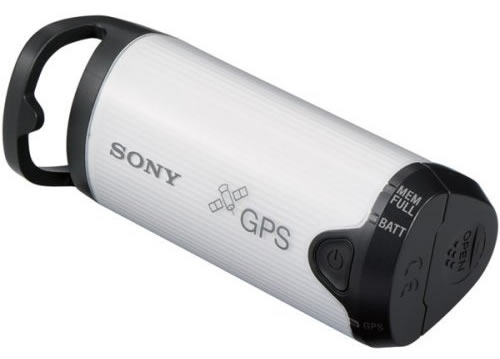
Sony Unit for Digital Still Cameras that I was quite intrigued. I actually first saw this unit about a year ago. However, when I read the reviews on Amazon.com I was a little less excited. Some were complaining that it didn’t work that well especially around tall buildings. So I kind of forgot about it until a few weeks ago when I was having dinner with my colleagues and Colin Fleming told me that he had one. So I had to ask, "does it work?" and more importantly, "would you buy it again?" His answers to both questions were YES! Then my next question was (knowing Colin is a Mac user), what app on the Mac did he use to marry the GPS data to the images? You see the Sony GPS comes with an app to add the GPS data that it captures to your images, however it’s Windows only. So Colin turned me on to HoudaGeo which is a $30 Mac app that does just that. It extremely simple and works great.
How does it work?
The concept is simple: You go out on a shoot (outside of course) and you turn on the Sony GPS. It starts a new log file on the device itself and once it connects to a GPS satellite it starts recording your coordinates and the time/date everywhere you go. Then you pick up your camera and start shooting. Since your camera is recording the date and time (very important that you have these set correctly in your camera) of every shot and the Sony GPS is recording the date and time coordinates at the same time all you have to do is match the images with the GPS log file when you return to your computer.
What’s my workflow?
Since I shoot primarily in Camera RAW and that there are no two camera manufacturers use the same RAW format, I use Adobe’s Digital Negative .DNG format (an open standard for Camera RAW files). The HoudaGeo app can’t embed the GPS data in proprietary RAW formats anyway. However, it can embed this data in .DNG files as well as JPEGs of course. Normally I would just import my images directly into Adobe Photoshop Lightroom. However, when I shoot landscapes and want to use the GPS data from the Sony GPS, I plug in my memory card into my Mac and then I use the FREE Adobe DNG Converter (Mac|Win)to convert my Nikon’s proprietary .NEF files into .DNG files directly from the memory card into a folder on my drive. I then use the HoudaGeo app to import the .DNG files and then the Sony GPS log file that contains all the GPS data. The 3rd step in the app is to click that actually writes the GPS data to the .DNGs (or JPEGs).
Once the images have the GPS data imported into them, I then import (reference) the images into Lightroom. From there I can do all the great things that Lightroom allows me to do, but I can also bring up any image in Lightroom and not only see the GPS longitude and latitude, but I can also click one button that automatically takes me to those coordinates in Google Maps and gives me a satellite view of where the shot was taken.

Here’s the shot I took at a nearby park
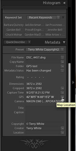
Here’s the GPS data showing for that shot in Adobe Photoshop Lightroom


After clicking the "Map Location" button in Lightroom, I was taken directly to a satellite view in Google Maps.
What’s hot and what’s not?
So far it works as advertised and it’s very easy to use. Basically just turn it on. However, there is definitely room for improvement. For example, there is only one status indicator that either blinks fast green when it has NOT locked on to a satellite or slow green when it has. Guys, how hard would it have been to use two different color LEDs or lights. Green is locked on and Red isn’t. I’m constantly looking at it trying to figure out "is that a slow blink or fast blink because there isn’t that much difference between them. Also Colin tells me that it doesn’t behave well when it’s dangling from say your belt, which is clearly the way it looks like you would use it. Instead I put a strip of velcro on it to attach to a vest or brim of a baseball cap (looks dorky, but it works). Lastly, it would have been nice to include a Mac app so that I wouldn’t have to spend an additional $30 for one. However, the HoudaGeo app is probably better than what Sony would have come up with anyway.
Would I buy it again?
So far the answer is yes! I’ve only used it in testing a few times so far, however each time it had no problem locking on to a satellite and since I don’t plan to use it much around tall buildings, that’s not a concern for me. I can’t wait to take it on my next trip out in the wild and shoot some of this country’s most beautiful landscapes. However, next time I’ll actually be able to "show" people "where" the shot was taken. Not sure how useful it will really be, but it sure is FUN! The
Sony GPSCS1KA GPS Unit Kit for Most Digital Still Cameras is $104.57 at amazon.com
Also check out this CNET article on the subject of Geotagging your photos.
I bought this little device some weeks ago and so far I’m pretty satisfied. Although it is not as accurate as I would have expected (sometimes more than 25 meters away from the actual location), I would buy it again as well.
As for the workflow, I use Lightroom as well to manage my photos. I usually shoot in Nikon’s RAW format .NEF and convert them into .DNG during the import in Lightroom. The only step that my workflow differs from yours is that I don’t use the Free DNG Converter. I import and convert the photos (without GPS data) to Lightroom and add the GPS data to the converted .DNG photos later. After that, I go to Lightroom and reload the metadata of the affected images to make the GPS coordinates available in Lightroom.
Cheers,
Thomas
Thomas, you’re absolutely right about it not being dead on accurate. If you look at my shot above I was standing in front of the barn. However, the GPS puts me off to the left of it. I noticed it right away, but then I remembered that consumer devices were not supposed to be that accurate when it comes to GPS. However, the ones in my car seem very accurate so, go figure.
Check out the GISTech PhotoTrackr http://www.gisteq.com/index-PT.html not perfect but better than the Sony and what I use.
Also remember these small devices do not have the same sensitivity that the GPS in an automobile have for many reasons such as size and power but in most cases they work fine to locate your photo location and even your trail in Google Earth.
Is that park in Southfield? I used to play in softball leagues there.
Joe,
Yep, that’s a park in Southfield.
A photo GPS tracker that I have been awaiting is the Jobo PhotoGPS. This device sits on the hotshoe of a dslr. The included one-step software not only codes GPS coordinates but also location, street, city, state, country data. According to the Website this product has been released. No price info is on Website but earlier promos listed a price of $149.
http://jobodigital.com/jobo_digital/photogps/gb/index.html
If this device delivers on its promises, it will be the state of the art.
I just wanted to mention that Breeze Downloader Pro (http://www.breezesys.com/) also reads GPS data from the Sony device. It integrates the GPS information with RAW files by creating an XMP file as it downloads photos.
Any GPS device which is capable of recording a track will do – possibly you already own one. Check the documentation of yours. My Garmin eTrex, normally used for hiking, works excellent and performs to a precision of up to 2m (under optimum conditions, of course).
For those who are not afraid of using a command line tool, why not try out gpsPhoto.pl. It is available for free and requires a gpx file containing your track to tag the metadata in your photographs. A lot of GPS software allows you for saving a track in gpx format, if yours doesn’t, GPSBabel will do in most cases. And yes, I prefer GPSBabel over Garmins software, because it is a lot faster to readout the device and convert the data to gpx.
Almost all GPS devices store track data. i.e. Garmin eTrax, GPSMAP could store it as GPX files on flash memory.
All what you need is apropriate software which could compare time of photo with time on track and record apropriate coordinats into metadata.
I spent a lot of time to find such tool for Windoes based system, but all my tryings were unsuccessfull and I wrote my own tool. And I dont need any new devices in addition to already mine GPS navigators.
Imageingester Pro is currently testing a beta version that, like Breeze, will import GPS info into raw files from many makers. It is available for windows and does many things the lightroom import will do, like batch metadata, keywording etc. Wicked fast app – i was an inital beta tester and the way Marc has improved the software has kept me using it over the built in adobe downloaders in cs3 and LR – it just works, and its small/fast. plus since he licenses it on a “per shooter” basis its perfect to load on a laptop @ the office, home and for the road since its just me shooting.
Regarding the GPS import – i use a Garmin GPSMAP 60c, and i plug it in via USB and hit go – as long as the clock is sync’d IIP will grab the tracklog and apply as needed.
(windows and mac too… which is wicked imho)
http://www.imageingester.com/
Wintec has the GPS logger WBT 201 with the program Time X Machine.
http://www.semsons.com/wiwbmu3gpsre2.html
http://www.wintec.com.tw/en/support_detail.php?cate_id=11&support_id=65
Terry, which Nikon dSLR are you using, a D200 maybe? In that case, and all of the professional dSLRs [D1-, D2- and D3-series] it is much easier to get GPS-data into photso – connect a suitable device to the camera’s 10-pin accessory jack. Apart from the cumbersome Garmin->Garmin cable->Nikon MC-35 cable->camera way there’s now several other, small and efficient and affordable, solutions from Red Hen, Dawn Technologies and [my personal recommendation] Custom Idea.
As other commenters noted, almost any GPS receiver nowadays keeps a track log, from cheap, small and easy to carry GPS mice like Wintec’s WBT-100 with Bluetooth to expensive, big and fully-featured Garmin or Magellan bricks.
Hi Dierk,
There’s a Nikon D300 on my shopping list. I currently use a D80 which doesn’t offer this ability. Thanks!
Yeah, this is a very very cool blog. 😉
I just added you to my favorites.
Thanx,
Mikey
Hello,
I was just at the Lightroom seminar in Hawaii and heard Scott mention the GPS adapter for the camera. I want to ask a stupid question, We sometimes have to record (picture) plants that we have had to hike a week to get to and sometimes we are out to sea collecting specimens, Will it work in such situations? I have a canon D5 (in out of the way areas)
Thanks Kris
Hi Kristen,
It should work anywhere where there is a clear view of the sky. However, it won’t work underwater. So if you’re out on a boat, you should be fine.
Hi Terry,
red your blog weeks ago and finally got the Sony Gps tracker. I just cannot find the tracker when I connect it to my MacBookPro, I am running still 10.4.11 as I am using a FileMaker sofware that is causing interference here in Europe. How will I get my gps track on my computer?
Regs from Ireland
Jürgen
Thanks for another great tech review. I’d seen this around but never saw a credible review on its accuracy, etc.
To answer a few previous questions, I doubt it would work under cover (trees, in buildings, etc.). Typically, you need a receiver with a higher sensitivity antanae.
I’d also recommend this post, which provides a basic review of several options for geotagging photos on the PC.
http://professionalsnapshots.com/blog/?p=40
You will be delighted to hear that HoudahGeo now has first-class manual geocoding using Google Earth. It lets you navigate and geocode your photos one by one or in groups right from within Google Earth. HoudahGeo is always up-to-date on which location in Google Earth you are looking at.
This feature has caused quite some excitement during demos at our Macoworld booth.
BTW, the Sony device is not compatible with Mac OS X 10.4.11, 10.5.0 or 10.5.1. I am not holding my breath for a fix in 10.5.2. Personally I use the Wintec WBT-201. I use Google Earth geocoding when I forgot to bring the Wintec or when I was indoors where it does not work.
Best,
Pierre Bernard
Houdah Software s.Ã r.l.
Terry,
Here is an update. Not sure if it is because of an upgrade or what, but the application HoudahGeo now will embed the .gpx data into RAW files. Or at least into Canon .crw files. You can check out my article here. http://thedigitaltrekker.com/news
GPS technology is already found in cars, boats, planes, construction equipment, film production equipment, agricultural machinery and even laptop Computer. GPS can give you many benefits
Terry,Best!
It lets you navigate and geocode your photos one by one or in groups right from within Google Earth. A 3.5 gps display with a touch screen interface makes it easy to select destinations.
I have a Solmeta N2. Along with the GPS data, it also records the magnetic heading. Nikon Capture N2 dsiplays the EXIF field as "Heading". How to I see the field in Lightroom 2? How do I add it to a Print > Photo Info > Custom Field? Thanks, Jeff
this is very good and informative blog ,
thank you for sharing information about gps.
I went ahead and bought the Sony GPS-CS1KASP GPS it’s neat! The best part the price isn’t too bad 🙂
how days there are lots of GPS devices r available in the market but seriously they r not too good.. than one of my friend said me about Gotek7 i just visit there page and i bought a GPS Tracker for vehicles , believe me or not its really very good i don’t have to pay any fees in every month no sim-card needed just plus and use very simply the build quality is very nice i like there services i think you should try once.